Thursday, October 14, 2010

Bibliography

From my research of continental drift, I have realized that evidence supporting this theory builds on one another and tying it all together. As new evidence is discovered, technology is developed and different branches of scientists contribute, the theory of continental drift seems more possible.
Photos:               

add book ones!!!!  

 1. (No Author) A Continental Drift Theory. http://www.openschool.bc.ca/boutique/samples/sc10_sample.pdf [Accessed September 20- October 14 2010]

2. (No Author) Continental Drift. http://www.sci.csuhayward.edu/~lstrayer/geol2101/2101_Ch19_03.pdf [Accessed September 20- October 14 2010]
3. (Various Authors) 2009.Continental Drift. http://cosscience1.pbworks.com/Lesson+10-1+Continental+Drift [Accessed September 27, October 3-14 2010]
4. (No Author) From Continental Drift to Plate Tectonics: The Evidence. http://einstein.byu.edu/~masong/HTMstuff/textbookpdf/C31.pdf [Accessed October 10-14 2010]
5. Earth- learning idea. The continental jigsaw puzzle. http://aegsrv2.esci.keele.ac.uk/earthlearningidea/PDF/85_Continental_jigsaw_puzzle.pdf [Accessed September 20. 2010]
6. Pathlights. 2006. Drift and Tectonics. http://www.pathlights.com/ce_encyclopedia/Encyclopedia/19plat01.htm [Accessed October 10 2010]
7. Sant. J. 2010. Wegener and Continental Drift Theory. http://www.scientus.org/Wegener-Continental-Drift.html [Accessed September 20. 2010]
8. WGBH Educational Foundation. 2007. Continental Divide- The Break up of Pangea. http://www.teachersdomain.org/asset/lsps07_int_biogeography/ [Accessed September 27, October 3-14 2010] 

Video:
Books:

1. Chidrawi, G. Hollis, S. 2008. Preliminary Biology in focus. Australia: McGraw Hill Education

2. Edwards, J. 2005. Plate tectonics and Continental Drift. London: Evans Brothers Limited

3. Gallant, R. 2003. Plates: Restless Earth. USA: Earthworks

4. Heffernan, D. Mahon, R. McDougall, J. Gillies, K. 2002. Earth and Environmental Science- Preliminary. Australia: Science Press

5. Knapp, B. 2000. Plate Tectonics. Europe: Atlantic Europe Publishing

6. Murck, B. Skinner, B. 1999. Geology Today- Understanding our planet. USA: John Wiley and Sons, Inc.

Websites:
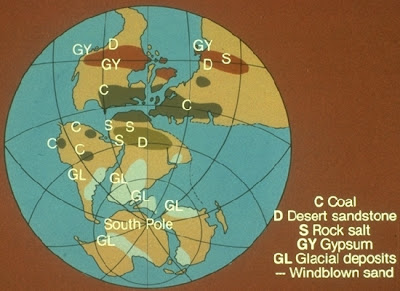
Palaeoclimates

As we are all aware of, our climate conditions are constantly changing. Therefore, different types of rocks or minerals are formed in different environments. The rocks or minerals contain clues about the climatic or environmental conditions under which they formed. These clues help palaeoclimatologists to piece together evidence that certain continent’s climates changed after the split of Pangea.
Evidence for this is that various rocks and minerals are found over different continents. The most significant change is evident in the spread of coal deposits.  Coal deposits found in colder places such as Antarctica suggest to palaeoclimatologists that Antarctica was once a warm environment, since coal is formed under warm temperatures. The idea was that if the continents were joined together, Antarctica would have been closer to warmer latitudes and since the split, spread over to the South Pole where it is colder.

Glacial Deposits

Since the formation of the Earth’s present atmosphere, the earth has experienced periods of temperature drops and rises. Therefore, sometimes if the temperature were to drop long enough, large ice sheets called glaciations would grow. During an ice age, these glaciations spread outward, leaving glacial deposits and possibly separating continents as the temperature changed.

Evidence to support this theory is the present distribution of glacial deposits from the Palaeozoic (past) glaciation. Glaciers of the same age are found in Africa, South America, India and Australia.  

The occurrence of glaciations in specific areas is very difficult to understand.

However, the next picture reveals with the continents rearranged, the areas affected by glaciations would fit perfectly. To strengthen this theory, the direction of ice movement indicated by arrows show that they are now consistent. The same way the geological formations are continuous across continents and the trends of fossil distribution.  Due to technology, glaciologists have also discovered the same age and rock deposits on matching sides.    

Direct Measurement

Now that scientists have discovered a way to calculate the age of ocean rocks and sediments. They then developed a process to measure the movement of the earth’s plates, since they move in all directions such as colliding, separating or sliding against each other.  


Direct Measurement in addition with laser measurements helps determine the rate and direction of individual plates that are moving. However, the interesting thing is that even though the plates move in one direction, different plates move at different rates. These forces created fault lines that caused volcanoes, earthquakes, and tsunamis.

The significance of knowing the direction of plates for the theory of continental drift, is that it explains a force responsible for the movement of continents. A problem Alfred Wegener was unable to explain when he first proposed his theory.

 As shown in the picture, near the South American plate and African plate there is an example of plate divergence, indicating that were joined but since then spread apart, due to the forces of plate movement.     

Tuesday, October 12, 2010

Age of Ocean Rocks and Sediments

The cross-geological formation was a major discovery, to the theory of continental drift. However, due to the continual changing rock-formation process, geologists were unable to establish which formations matched. To resolve this problem, they tried to match up similar age and rock types.  

To determine the exact age of a rock, scientists used the method of radiometric dating. They found that rocks towards the edges of mid-ocean ridges are younger than those further in from the margins. Before this, scientists were unfamiliar with what happened on the ocean floors. Until, various research vessels discovered huge undersea ridges across the floors of the oceans. It was then that they understood that new ocean crust was continually being created.

By 1965, oceanographers Maurice Ewing and Bruce Heezen had shown that various ocean ridges were connected as a vast water mountain range around the globe. Then in the early 1960's the idea of seafloor spreading was established. The idea suggested that heat currents deep within the planet were continuously changing the surface of the earth and was the force that allowed the continents to separate.  This idea helped Wegener to explain how the continents may have moved, which, as mentioned in an earlier blog, was the biggest problem with understanding his theory. (Sea-floor spreading animation: The animation helped me understand how mid-ocean ridges are formed by sea-floor spreading.)
When the age of sea-floor rocks are mapped out, it can be easily seen how some continents match up. The best match is between the continents Africa and South America. As shown in the picture there is some similarity between the ages of rocks especially about 550 million years old, which once again suggests that the continents were once joined together.
Another addition to this, is the pattern of sediments on the sea floor near the ridges. If the oceans were very old and unchanging, the ocean floors should be level and covered in layers- the oldest at the bottom and the youngest at the top. However, oceanographers have found that the sediments are thickest near the continents and there are little or no sediment at the mid-ocean ridge. Therefore, contributes to how the ages of rocks are older as they move further away from the ridge. The picture helps demonstrate the layering of sediments on the ocean floor.                                                                

Sunday, October 3, 2010

Fossil Distribution

If the continents were really once joined together at one time, with matching geological features, Alfred Wegener believed that there would be matching plants and animals on either sides of matching continents. To check this hypothesis, Alfred Wegener turned to the fossil record. It revealed that identical fossilized plant and animal species have been found in many different places, on different continents. It suggested that they evolved together as the continents were together and after the split, evolved separately.
To help support the understanding of fossil distribution, biologists contribute by giving further evidence explaining how some animals come from a common ancestor but evolved into various types resulting from differences in their environment, which ties in with the theory of evolution.
Many of the species that lived at the time are now extinct and so fossils provide the only record to show how they were distributed. The picture below shows that when the continents are fitted together, the distribution of fossils form a continuous pattern just like the matching of geological formations.
By looking at the map, it seems impossible for such similar organisms to exist so far away from each other, unless these life forms once lived all together on a single continent. Wegener stated that these organisms could not have crossed the vast oceans by simply swimming or being carried by wind or water.
An example is the ancient fern Glossopteris. Many believed the seeds of this plant had been carried by wind or water across the continents. However, the seeds of Glossopteris were large and heavy and therefore it was unlikely they could be carried far, let alone whole landmasses.
Some geologists had suggested that land bridges once linked continents, enabling animals to travel back and forth between the separated continents. The idea of land bridges to me, would be a logical reason to explain why similar fossils are being found on different landmasses. Most scientists believed that after the lowering of sea level during an ice age, it allowed animals to cross the narrow Bering Strait between Asia and North America. To prove land bridges still exist, pieces of its remains should still lie below sea level. However, no signs of any land bridges have ever been found in the Atlantic Ocean.
The video helps illustrate  the change in sea level from the peak of the last ice age to the present.
The evidence of fossil distribution and cross-geological formations were major discoveries that contributed to my understanding of continental shapes and how the continents were once joined together.